NISAR S-SAR Data Products Release
S-band data through Bhoonidhi Data Portal
The NASA–ISRO Synthetic Aperture Radar (NISAR) mission, a joint Earth observation initiative of ISRO and NASA, was successfully launched onboard GSLV-F16 on 30 July 2025 from Satish Dhawan Space Centre (SDSC-SHAR). NISAR is the world's first spaceborne SAR mission employing dual-frequency radar instrumentation, comprising NASA's L-band SAR and ISRO's S-band SAR, operating with the advanced SweepSAR acquisition technique to enable wide-swath, high-resolution imaging. The satellite has been placed in a 747 km altitude Polar Sun-synchronous orbit with an inclination of 98°, facilitating global repeat observations. With a nominal 12-day repeat cycle, NISAR enables systematic monitoring of Earth system processes including natural hazards, ecosystem dynamics, agricultural monitoring, cryosphere evolution and surface deformation.
NISAR S-SAR Daily Processed Data Collection
ISRO has released the NISAR S-Band SAR Daily Processed Data Products through the Bhoonidhi portal. The data comprises of S-Band SAR acquisitions over the Indian landmass, along with global locations spanning across diverse NISAR science themes, acquired in accordance with the ISRO observation plan.
The current release includes the following data products:
| STANDARD PRODUCTS | INTERFEROMETRIC PRODUCTS | OFFSET PRODUCTS |
| L1-RSLC (Range-Doppler Single Look Complex) | L1-RIFG (Nearest-Time Interferogram) | L1-ROFF (Range Doppler Pixel Offsets) |
| L2-GSLC (Geocoded SLC) | L1-RUNW (Nearest-Time Unwrapped Interferogram) | L2-GOFF (Geocoded Pixel Offset Product) |
| L2-GCOV (Geocoded Polarimetric Covariance Matrix) | L2-GUNW (Geocoded Nearest-Time Unwrapped Interferogram) |


Product Generation and Latency
Generation of the NISAR S-Band SAR Level-1 and Level-2 products utilizes the most accurate orbit solutions to achieve the required geolocation and radiometric accuracy. Consequently, the daily processed products are made available to users with an operational latency of approximately 48 hours from the acquisition time, subject to availability of the accurate orbit information.
Calibration Status
The current release includes the most recent radiometric, geometric, and polarimetric calibration applied to the S-Band SAR data. This may further get revised as the mission progresses and users will be notified of future updates.
Product Baseline Version: 1.4.0
Composite Release ID (CRID): P00500
Users may observe residual radiometric banding in low signal-to-noise ratio (SNR) regions such as oceans, deserts, and other homogeneous surfaces in this version of products. Although, RFI mitigation has been applied to all scenes, residual RFI artifacts may still be present in certain areas, for which improvements are planned in future releases.
Products generated under Urgent Response (UR) and Near Real-Time (NRT) modes may contain partial observations (for example, reduced swath coverage or a single polarization) to enable rapid dissemination. These products will be replaced once the corresponding full swath products are generated.
Adapting to Sweep-SAR Data
NISAR is the first operational mission implementing SweepSAR technology. One of the primary advantages of SweepSAR imaging is wide-swath imaging with fine resolution. SweepSAR imaging enables wide-swath observations by extending the radar echo reception interval to accommodate returns from a large range extent. As a consequence, radar pulse transmissions may occur while echoes from previously transmitted pulses are still being received. Since the SweepSAR architecture utilizes a common reflector for both transmit and receive operations, echo reception is temporarily interrupted during pulse transmission intervals. These interruptions result in localized regions of missing observations within the receive window, commonly referred to as transmit gaps or dead ranges.
Fixed PRF Mode vs Dithered PRF Mode
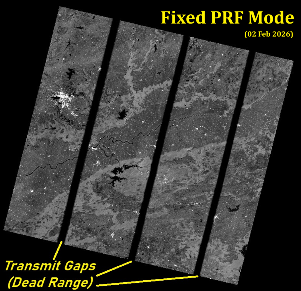
Fig 1: NISAR SSAR Image acquired in Fixed PRF mode, showing transmit gaps
Pulse Repetition Frequency (PRF) determines the time difference between two transmitted chirps (which are high BandWidth frequency modulated signals transmitted and its echo is received). In Fixed PRF mode, the timing between two subsequent pulses throughout the duration of imaging is constant. This causes the Transmit Gaps to occur at the same position in the reception window. During Image Focusing operation, the alignment of dead-ranges in range time causes a black (low backscatter) region to appear at the same swath location in range direction. Since, all the pulses have the dead-range in the same location, it appears as a black-band spanning in the azimuth direction.

Fig 2: NISAR SSAR Image acquired in Dithered PRF Mode of Imaging, mitigating transmit gaps
The Dead Range in between the images are mitigated with an innovative combination of System Engineering and Signal Processing. The PRF is not maintained uniform but rather it is modified in a pattern of fixed repetition length. This causes the Transmit gaps of each corresponding line to be not aligned with the transmit gap of the previous line. This process is called dithering, and using Best Linear Unbiased Estimation technique, due to availability of adjacent pixel information in azimuth direction, and the nature of RAW signal property, the dead range pixel information can be estimated. This provides a final image after focusing without transmit gaps in this mode of imaging as shown above.


